Wow, that surprises me… I thought Melbourne would have ranked ahead of Sydney and Brisbane.
No rail link to Tullamarine Airport would have counted against it significantly.
Wow, that surprises me… I thought Melbourne would have ranked ahead of Sydney and Brisbane.
No rail link to Tullamarine Airport would have counted against it significantly.
I can’t believe we beat out any other Australian capital, considering RailFail and the clusterfuck which is Queensland Rail.
Melbourne’s PT is terrible - particularly its trains and buses. The trams are the only shining point, but they don’t actually cover a great deal beyond the inner suburbs. That’s why Sydney’s PT usage rate is about double of what Melbourne’s is.
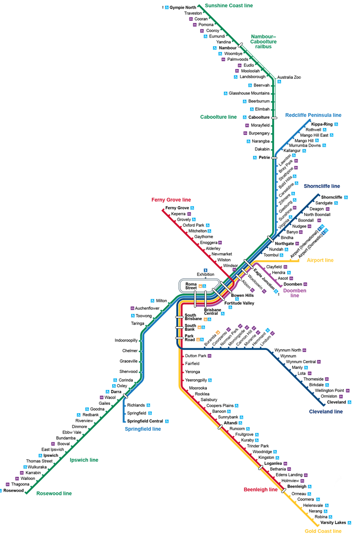
Brisbane…yeah, those busways are ace. The level of public transport available is very impressive for a city with only 2.5 million in the metro area.
I suspect the report only took into account the routes and timetables published by the authorities, and reliability issues (i.e. the recent train failures of QR) weren’t factored in.
The reach of Brisbane’s PT system to the Gold and Sunshine Coasts I’m sure would have had an impact (Sydney classifies Newcastle and Wollongong trains as long distance rather than metro network).
As a regular user, it can be improved.
The busways have services every 2 minutes but suburban lines are seriously wanting. In peak times, the two lines near me (116 and 112) come once every 30 minutes. This could be improved if they rerouted lines to feed into nearby train and busway stops instead of going all the way into the city (which clogs up roads). Loop feeder services could then go to 15 or even 10 minute peak time intervals, which would be amazing. Translink tried to do this but local dolts got all worried they were losing their “iconic” (the actual fuck?) bus routes.
They also need to expand the busways further, and that should seriously be considered in light of Metro. Both Chermside and Carindale have no train connection and would benefit immensely from a busway like Garden City/Mt Gravatt has. Chermside is already becoming a high density suburban business hub and Carindale will get there in the next five years.
The busway to Carindale will be easy because the median along Old Cleveland Road is wide and still has the old tram tracks, and the busway is already built halfway there. Chermside will require tunnelling unless city council forces people from homes.
Metro should’ve become light rail instead of this weird bi-art bus concept, but I have read that the per hour passenger capacity is exactly the same either way so maybe it makes sense. The new Cultural Centre station will be the biggest benefit however; current CC is awful and extremely cumbersome to get to from surrounds.
Rail needs to get Cross River Rail sorted asap. Once that’s done, capacity will be available for a new line to Jimboomba which already has preserved land.
It was announced late Sunday night that four of Melbourne’s busiest rail lines will have no direct trains to and from the CBD in the first five days of December, with buses replacing trains on the Glen Waverley line between Richmond and Darling, and on the Belgrave, Lilydale and Alamein lines between Parliament and Camberwell, all day from Friday to Tuesday. The official reasons given are maintenance and projects works, but there are no level crossing removals works planned for the two sections, and the Melbourne Metro project is nowhere near them, so we can only speculate what kind of project requires such a long shutdown on these four lines.
Summer’s coming so perhaps work to try and avoid a repeat of …

Apu: Is there a chance the track could bend?
Lyle Lanley: Not on your life, my Hindu friend.
![]()
Most likely signalling works
I researched the Sydney train network out of interest and came across the map. Can someone tell me why half the train network is technically one line (T1)? It could be 5 or 6 lines if they split it up. How to people know which T1 service goes where?
![]()
Melbourne’s is just as confusing too.
It’s changing in a couple of weeks time.
You have three lines combined; Northern, North Shore and Western.
Northern and North Shore trains become Western Line trains at Central. So Hornsby to Central (via Macquarie University or Gordon) becomes Richmond or Penrith/Emu Plains bound trains at Central and vise versa.
The Northern Line section between Strathfield and Epping have their own services (Epping via Strathfield)
Coming from the West (i.e. Parramatta) the trains are Hornsby via Macquarie University or Hornsby via Gordon. Going west (from Central), Penrith/Emu Plains or Richmond via Parramatta.
Note that the Epping to Chatswood section will close soon as it gets converted to metro.
Your explanation and the new map helps but that still drives me nuts.
This is how it was before the combination for T1 and the Epping to Chatswood section. Maybe that is what you’d prefer?
After the Epping-Chatswood Link opened:
Yep. Colour coding that combines lines still doesn’t solve the basic problem - we call trains after their destination - so if something’s stopping short of the end of the line - you have to have a knowledge of what stations are on what line to know it’s still your train.
Sure, you eventually learn - but by that point a colour isn’t helping you either.
You’d think combining it with a number code in Sydney could have fixed this - number each of the sub routes - like have a T16 be an Epping train - or more complex stuff like a T164 be an Epping train that terminates at Meadowbank (the 4 being the count of stops before the end of the line).
And don’t expect this to be fixed in any way until 2030 or so: that’s when the final stages of the PTV Development Plan should come in to force, and hopefully the last time the different lines are regrouped (which they are expected to do two or three times over the next couple of decades)
I visited the Transport NSW website after reading your post. It’s not just the Sydney train lines are changing, but also the city’s entire public bus and ferry system with new routes and timetables. The scale is enormous. Usually timetable changes happen one mode at a time and one region at a time, not the whole city. The NSW Government will be praying there will be no transport chaos when the changes come in force at the end of this month.
Just on the trains, the south west is most affected, with direct trains between the CBD and Leppington for the first time, but Campbelltown/Macarthur not only loses trains to/from the city via Liverpool, but also direct trains to/from Parramatta. It means passengers will have to change trains twice if they are going to Parramatta for work or sport.
Leppington has direct trains to the CBD (via Granville) since December 2015, when the South West Rail Link was integrated into the rest of the rail network.
Also, passengers from Campbelltown will only need to change trains once at Glenfield to get to Parramatta, as there will be direct trains from Leppington to Parramatta & Blacktown.
When the Macquarie park section closes for metro conversion will trains run from Hornsby to central via Meadowbank/Rhodes like they used to? When is that closure happening?
Bingo. That’s what’s done in most European cities. One line is one colour, save for the occasional branch. London Underground is an exception but only because its network is so huge and every stop has frequent services.
Brisbane follows the same logic and I sincerely hope they don’t take inspiration from Melbourne and Sydney. Even Perth is guilty.
It’s almost like the people in charge would want people to get lost with having the colour system for multiple lines.
Simple solution - change the colour. If it’s due to the line being the northern area and that’s red, change the tone or shading to something close, yet distinguishable like a light red/pink.
That Sydney map gives me a headache holy crap it’s confusing.


