Signal: An Australian transmitter map with real coverage modelling – now available in beta
If you’ve been reading this thread, you know that I’ve been building a site called Signal, and it’s at the point where I’d like some actual users on it rather than just me: https://signal.ozdatahub.com
It’s a full-screen map of every licensed broadcast transmitter in Australia, built from the ACMA RRL and refreshed daily. That’s currently 8,527 active services – 2,906 FM, 2,717 TV, 2,482 narrowcast (LPON/NAS), 324 AM and 63 DAB+.
Not all features are live yet, but here’s what you can do with it currently:
- Explore: Click any transmitter for its licence details, site, ERP, antenna height and directional pattern, plus the services running on it
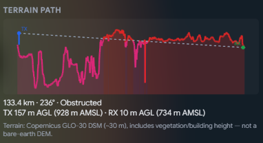
- Receive Here: Set your location and it models what you should actually receive at that spot: terrain-aware (ITM), using each transmitter’s real directional pattern, your antenna height and receiver setup. Works anywhere in the country.
- Coverage*: Pre-rendered terrain-modelled coverage maps (*within 500km of Sydney for now)
- Listen: around 3,200 services have a stream linked for when you want to cross-check a DX catch with a particular stations
- Tropo forecast: a rolling ducting forecast over Australia built from NOAA GFS data, refreshed through the day, with past and forward time steps.
- Bandscan and logbook (alpha): tools for tropo chasing and logging what you hear
Where the coverage maps are up to
The detailed FM coverage layer is computed site by site on a fleet of six PCs, but it is still a very long process (i.e. months). Right now, the area within ~500 km of Sydney is complete for FM (and about ~250 km for TV). Melbourne, Brisbane, Adelaide, Perth and Darwin are queued next for FM and TV and being computed now – they’ll fill in over the coming weeks. AM, MF-NAS, DAB+, VHF-NAS and SW modelling is already complete nationwide.
Everything else still works everywhere: every transmitter in the country is on the map with full details, and Receive Here models your location live regardless of whether the pre-rendered maps have reached your area yet.
It’s a beta and it will have rough edges. There’s a bug-reporting button built into the site – please use it, including for data that looks wrong. Station naming, networks and ownership are the areas I’d most value corrections on; the licence data is ACMA’s, but how stations are grouped and labelled is my own work and it’s the part most likely to be wrong.
Browsing the map needs no account. Receive Here, the logbook and the bandscan tools need a free one, mostly so the heavier modelling isn’t open to the whole internet and so that your location can be saved.
The site will work on mobile, but it’s a much better/optimised experience on desktop, given how much information it conveys.
A note also that it may go down at any time for new features to be added or for bugs to be fixed.
I’ve posted this here for now, but not sure if it’s better for this to have its own thread so that feedback doesn’t clutter up the DX thread.
Enjoy! 

 .